TatukGIS Viewer 4.4

Free The TatukGIS Editor is a desktop GIS mapping and data editing application
3.3 
Rating
Your vote:
Latest version:
4.4.0 See all
Developer:
Screenshots
1 / 11
Awards (2)
Show all awards
Software Informer Editor Rating 4
Download
Free  

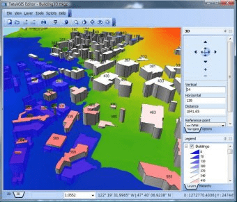
The TatukGIS Editor is a professional-level, desktop GIS mapping and data editing application designed to be easily learned and used. The default user interface intuitively presents features most used and valued by most GIS users, while remaining free of excessive menu clutter. Specialized or custom features are supported via a built-in scripting environment with object API.

Editorial review:
Read a full review

Comments

3.3
Rating
3 votes
5 stars
1
4 stars
1
3 stars
0
2 stars
0
1 stars
1
User

Your vote:

Related software

FastStone Image Viewer
Free
rating

Manage, view, edit and convert your images in batches.

EPS Viewer
EPS Viewer
Free
rating

A tool that allows you to visualize images saved in EPS format.

CAD Viewer
CAD Viewer
rating

View, print and convert CAD files.

Gis Weather
Gis Weather
Free
rating

Customizable weather widget for Windows users.

Getmapping Viewer
Getmapping Viewer
Free
rating

Easy to use aerial photo and mapping viewer

Related suggestions

Tags

Free GIS viewer Data editing GIS Viewer Slim version 3d map display Gis mapping TatukGIS Viewer Download GIS viewer GIS vector Viewer Desktop